Beyond Gentrification is a spatial narrative that examines Community District 102 (CD102) in New York City through the lens of cultural preservation under displacement pressure. Using ArcGIS StoryMap as the primary medium, the project weaves together four interconnected dimensions—culture, open space, mobility, and resilience—to argue that defending neighborhood identity requires systemic, multi-layered intervention rather than isolated policy responses.
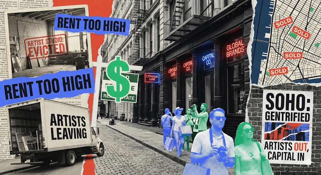
Gentrification is often framed as an economic process—rising rents, new developments, shifting demographics. But in neighborhoods with deep cultural roots, displacement is not just a housing issue. It is an erasure of identity: the loss of gathering places, vernacular landscapes, transit-dependent mobility patterns, and community resilience networks that took generations to build.
CD102 represents a critical case study. The district faces accelerating development pressure while maintaining a rich cultural fabric that is spatially embedded—tied to specific streets, parks, transit corridors, and gathering spaces. This project asks:
What does gentrification look like when measured not by property values, but by the survival of cultural infrastructure?
The StoryMap is structured around four interconnected lenses, each revealing a different aspect of how cultural identity is spatially produced and threatened:
Culture
Mapping the cultural anchors of CD102—community organizations, religious institutions, cultural venues, and informal gathering spaces—and tracing how their spatial distribution creates a legible cultural landscape. The analysis reveals which blocks and corridors serve as cultural connective tissue and how their loss would fragment community identity.
Open Space
Examining how parks, plazas, streetscapes, and informal open spaces function as sites of cultural expression and community life. The analysis goes beyond acreage and access metrics to consider how open spaces are actually used, by whom, and what kinds of social and cultural practices they support.
Mobility
Analyzing how residents move through and connect with their cultural landscape. Transit access, pedestrian networks, and commuting patterns reveal which cultural anchors are accessible to whom, and how mobility infrastructure either reinforces or undermines cultural cohesion.
Resilience
Assessing the district's capacity to absorb displacement pressure while maintaining cultural identity. This dimension synthesizes the previous three, identifying which areas have overlapping cultural, spatial, and mobility strengths—and which are most vulnerable to cultural erasure.
The project integrates multiple data sources and analytical approaches:
- Geospatial data from NYC OpenData, census records, and community surveys
- Overlay analysis combining cultural asset locations, open space access, transit networks, and demographic change indicators
- Narrative cartography using ArcGIS StoryMap's scroll-driven map transitions to guide readers through spatial arguments sequentially
- Multi-scale analysis moving between district-wide patterns and street-level observations
The StoryMap format allows each data layer to be introduced contextually, building the reader's understanding incrementally rather than presenting all variables simultaneously.
The project delivered:
- A published ArcGIS StoryMap presenting a multi-dimensional analysis of cultural displacement in CD102
- A framework for evaluating gentrification through cultural infrastructure rather than purely economic indicators
- Spatial identification of culturally critical corridors and vulnerability hotspots
- A narrative design that makes complex spatial relationships accessible to community members, planners, and policymakers
This project reinforced that effective urban analysis requires moving beyond single-variable explanations. Gentrification is simultaneously a cultural, spatial, mobility, and resilience phenomenon—and addressing it requires tools that can represent this complexity without losing clarity.
The StoryMap medium proved particularly suited to this challenge. By controlling the sequence in which readers encounter data layers, the narrative builds understanding that a static dashboard or report cannot achieve. The experience deepened my interest in spatial storytelling as a bridge between technical analysis and community-facing communication.